
I recently attended an insightful seminar by Hugh Sinclair, a renowned lecturer from the University of Edinburgh, where he discussed his research on the dynamic river catchments of the Himalaya.
The Himalayas form a mountain range in Asia, separating the plains of the Indian subcontinent from the Tibetan Plateau. Some of the world’s major rivers — the Indus, the Ganges and the Tsangpo-Brahmaputra — rise in the Himalayas, and their combined drainage basin is home to roughly 600 million people.
River courses continuously change and migrate. In regions of high rainfall, and where sediments are soft, rivers are easily eroded, often resulting in floods (due to their banks bursting). This can be particularly devastating when it occurs near areas with high populations. Thus, it is important to be able to predict the future course of a river in order to minimise the damage caused.
A drainage divide is an elevated area, such as the mountains in the Himalaya, which separates different river catchments. It is suggested that tectonically driven changes in river catchment shape may be modified by river capture and progressive migration of drainage divides in response to rock strength and changing river base-levels. The competition between tectonic deformation of river catchments and the response of the rivers is highlighted across the Himalaya where all of the big rivers are characterised by steepened reaches.
It is suggested river catchments may be deformed during crustal strain. Hugh and his team explored the role of tectonics in Himalayan catchments, and they found that faulting (in the form of thrust faults) plays a vital role in the deformation of river catchments. The main central thrust (MCT), based in the front of range of the Himalaya, has been the primary cause of deformation in this region, and explains why the front of range is more ‘dynamic’ than the lee (area behind the Himalayas).
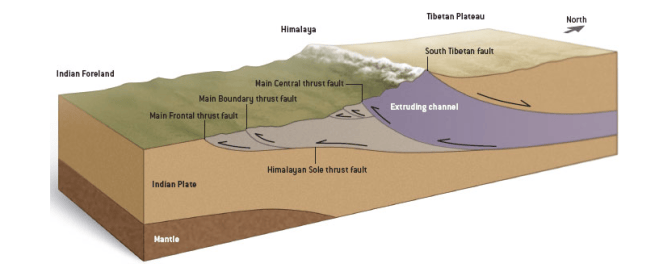
Block diagram illustrating the basic tectonics of the Himalaya – Indian plate being pushed downwards underneath the Himalaya’s
Hugh and his team found that in the lee of the Himalaya the drainage divides move at a rate of 0.2km/Myr, only 1% of the speed that occurs in the frontal range of the Himalaya (~20km/Myr). In comparison to the frontal range, the lee range shows very slow rates of narrowing and deformation.
Hugh also discussed the use of the Chi parameter in his work. Drainage divides are mobile and the tendency they have to migrate can be mapped using the Chi parameter. The migration of a drainage divide is determined by its erosional capability (the softer the rock, the easier it is to erode), which explains the slower rates of movement observed in the lee of range (rock strength is harder than that in the front of range). Divide migration in the Kathmandu valley (front range of the Himalaya) is evident as the gradient of the river is lower than surrounding area.
Hugh and his team suggest that the drainage divides in the lee of range are moving extremely slowly, whilst the drainage divides in the front of range migrate much faster. The front of range catchments compete in response to base level changes driven by tectonics and deformation, which triggers erosion. If deformation is more than the rate of erosion, then the river valleys will narrow (as seen in the Kathmandu valley).
Sinclair’s seminar highlighted the importance of tectonics and its role in changing river catchment dynamics.
Thanks again Hugh!
 Geo takes GEOscience